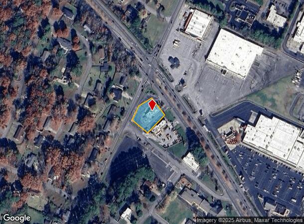
Property Record
925 25Th St Nw, Cleveland, TN 37311
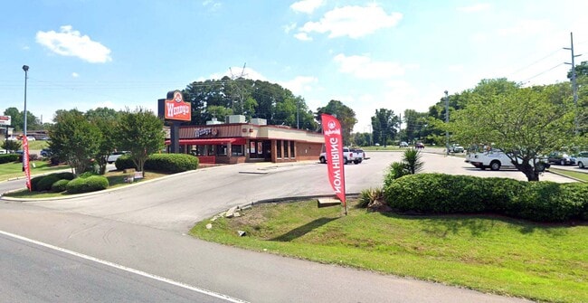
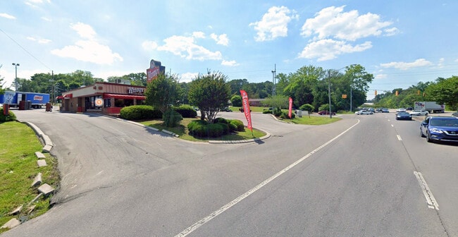

This Property Is For Sale
NEARBY LISTINGS FOR SALE OR LEASE
Property Detail
925 25Th St Nw
Cleveland, TN
Mcclary West Hgts
041M-K-001.01
MCCLARY WEST HGTS PB: 2 PG: 164 BLK: A LOT PT 1 2 & 6; WENDYS 141X205.8;129X162 M
Commercialnec
Bradley
X
Tennessee
47065C0300G
1
2024
0.59 AC
2025
Downtown Cleveland
010700
Other Market Areas
2,326 SF
DEMOGRAPHICS near 925 25Th St Nw
1 Mile
3 Mile
5 Mile
2024 Total Population
7,301
45,079
76,324
2029 Population
7,673
47,565
80,504
Pop Growth 2024-2029
+ 5.10%
+ 5.51%
+ 5.48%
Average Age
41
39
40
2024 Total Households
2,918
17,836
29,775
HH Growth 2024-2029
+ 5.52%
+ 5.73%
+ 5.66%
Median Household Inc
$46,970
$48,189
$53,353
Avg Household Size
2.30
2.40
2.50
2024 Avg HH Vehicles
2.00
2.00
2.00
Median Home Value
$236,078
$231,154
$216,202
Median Year Built
1972
1981
1984
Nearby Places
- Restaurants
- Banks
- Shops
- Fitness
- Groceries
PUBLIC TRANSPORTATION
AIRPORT
Lovell Field
DRIVE
WALK
Distance
Lovell Field
35 min
25.3 mi
Freight Ports
Georgia Ports - Savannah
DRIVE
WALK
Distance
Georgia Ports - Savannah
423 min
369.3 mi
Nearby Properties
Address
Land Use
TOTAL SIZE
Lot Size
Zoning
Address
Land Use
TOTAL SIZE
Lot Size
Zoning
400,000 SF
123.44 AC
IH
Address
Land Use
TOTAL SIZE
Lot Size
Zoning
357,110 SF
52.96 AC
FAR
Address
Land Use
TOTAL SIZE
Lot Size
Zoning
267,460 SF
8.30 AC
IL
Address
Land Use
TOTAL SIZE
Lot Size
Zoning
118,230 SF
37 AC
FAR
Address
Land Use
TOTAL SIZE
Lot Size
Zoning
88,644 SF
46.37 AC
R1
Address
Land Use
TOTAL SIZE
Lot Size
Zoning
93,264 SF
10.20 AC
CH
Address
Land Use
TOTAL SIZE
Lot Size
Zoning
68,785 SF
8.70 AC
R1
Address
Land Use
TOTAL SIZE
Lot Size
Zoning
356,920 SF
26.42 AC
IL
Address
Land Use
TOTAL SIZE
Lot Size
Zoning
620,857 SF
34.28 AC
IH
Address
Land Use
TOTAL SIZE
Lot Size
Zoning
213,240 SF
19.10 AC
R3
Address
Land Use
TOTAL SIZE
Lot Size
Zoning
74,392 SF
15.69 AC
MU
Address
Land Use
TOTAL SIZE
Lot Size
Zoning
203,778 SF
13.46 AC
R3
Address
Land Use
TOTAL SIZE
Lot Size
Zoning
170,518 SF
4.96 AC
CH
Address
Land Use
TOTAL SIZE
Lot Size
Zoning
416,503 SF
61.92 AC
CH
Address
Land Use
TOTAL SIZE
Lot Size
Zoning
50,400 SF
1.04 AC
CBD
Address
Land Use
TOTAL SIZE
Lot Size
Zoning
153,044 SF
16.85 AC
PUD
Address
Land Use
TOTAL SIZE
Lot Size
Zoning
196,358 SF
16.50 AC
A
Address
Land Use
TOTAL SIZE
Lot Size
Zoning
74,229 SF
1 AC
R1
Address
Land Use
TOTAL SIZE
Lot Size
Zoning
132,758 SF
12.30 AC
PUD
Address
Land Use
TOTAL SIZE
Lot Size
Zoning
421,180 SF
27.10 AC
IL
Address
Land Use
TOTAL SIZE
Lot Size
Zoning
141,489 SF
10.40 AC
R3
Address
Land Use
TOTAL SIZE
Lot Size
Zoning
48,494 SF
4.70 AC
R3
Address
Land Use
TOTAL SIZE
Lot Size
Zoning
36.78 AC
PI
Address
Land Use
TOTAL SIZE
Lot Size
Zoning
96,527 SF
5.15 AC
CH
Address
Land Use
TOTAL SIZE
Lot Size
Zoning
56,725 SF
13.10 AC
R1
Address
Land Use
TOTAL SIZE
Lot Size
Zoning
44.30 AC
IH
Address
Land Use
TOTAL SIZE
Lot Size
Zoning
203,751 SF
18.81 AC
CH
Address
Land Use
TOTAL SIZE
Lot Size
Zoning
30,526 SF
0.92 AC
CBD
Address
Land Use
TOTAL SIZE
Lot Size
Zoning
122,596 SF
5.98 AC
PUD
Address
Land Use
TOTAL SIZE
Lot Size
Zoning
136,793 SF
61.89 AC
CH
The World's #1 Commercial Real Estate Marketplace
Connect with us
© 2025 CoStar Group
The information above has been obtained from sources believed reliable. While we do not doubt its accuracy we have not verified it and make no guarantee, warranty or representation about it. It is your responsibility to independently confirm its accuracy and completeness. Any projections, opinions, assumptions, or estimates used are for example only and do not represent the current or future performance of the property. The value of this transaction to you depends on tax and other factors which should be evaluated by your tax, financial, and legal advisors. You and your advisors should conduct a careful, independent investigation of the property to determine to your satisfaction the suitability of the property for your needs.